From the boat or when on the causeway, we can see that there is more structure at the SpaceX facility. We though this might be a good morning to go check it out on the scoots: the temp was in the upper 70s, almost no wind, reasonable humidity... we left the house before 8:00...
Reasonably light traffic through town, and then a left turn onto Hwy 48 that takes you to Brownsville...
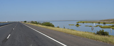
The photo above shows water in the low area just off the roadway. And below, the Port of Brownsville...
It is an active port: they build and refurbish oil platforms there. With oil being depressed, the port is also an active ship wrecking facility; three companies dismantle ships for the scrap metal. And the usual import/export of oil, steel, grain, gravel, etc.
Just past the port, we turn south.
South to Boca Chica Road, then turning east for the 18 mile run out to SpaceX. Into the sun...
The eastbound view of the Border Patrol Inspectation Station...
The road has recently been chip-sealed; not perfect, but an improvement over the last time we were on it (last year). In the distance, we start to see some of the structures at the SpaceX facility...
There is a lot of nothing out here; the terrain is flat - that is the waters of South Bay that you can see in the far left of the photo above. Getting closer...
I was surprised by the number of cars in the parking lot and alongside the road as we approached the facility...
This is way more than what you'd expect from the usual construction workers - there must be something going on here today. Pretty much every place you could park a car was occupied...
We rode past the main facility, heading for Boca Chica Beach and the SpaceX testing facility. Until...
The road was blocked. Local and State Police at the barricades. As I pulled up to the barricade, one of the officers asked me, "How did you get in here?"
"We're just out for a ride - wanted to see what the new construction was here."
He said, "This entire road is closed, all the way from Brownsville. Did you drive around the unit on the road?"
I said, "There was a police vehicle right where the road construction signs were, but there was no one in the vehicle and it was parked in the center turn lane. There were no 'Road Closed' signs anywhere along the way, just construction signs."
"There was no one in the vehicle?" he asked. I'm guessing someone is going to be in trouble.
"No. It wasn't parked like they were trying to stop traffic. We don't want to cause any issues for anyone - we'll just turn around and head back home," I said.
"Where's home?"
"Port Isabel. We're just out for a pleasant ride before it gets too hot. Is there a launch today?"
"Just part of routine testing. Ride safe, sir."
It wasn't an unpleasant exchange, once he could see we're just a couple retired folks out for a ride. I didn't see anything in the local media about any activity at SpaceX today. We turned around, riding past the facility again...
Plenty of standing water from Saturday's storm. Here's a "drive by" video from NASA taken after the storm...
https://www.youtube.com/watch?v=rlQStZ7LfG8
Heading west once again, there are a couple curves...
Not anything we'd consider sporting, though. Easier on the eyes going west at this time of day. We passed this just north of the road...
They waved us through without stopping. We are close to the Mexican border here. How close? That's a portion of "the wall" at the center of the image...
And then, we were back in Brownsville again. We turned north to get back to the highway; shared the road with this "Oversize Load" before our turn on the entrance ramp...
Plenty of truck traffic around the Port area. We turned east on Hwy 48, once again looking into the sun...
Back into Port Isabel, someone with the power pole construction project finally got smart: they made two lanes heading towards the island, one lane heading away...
We pretty much had our own unoccupied lane this early in the day. The traffic heading inland from the island was backing up, though - because of the stop lights in town and narrowing down to one lane that direction. Joan asked, "How tough could it be to move a few cones and make it two lanes for whichever direction needs it at the time?" Monday morning - yeah, people heading off the island after the weekend.
Highway 100 is 4 lane all through town; traffic normally flows reasonably. During summer weekends, they generally have the traffic light flashing yellow to keep traffic flowing off the island on the weekends. I guess the traffic control people don't think that's necessary, yet. There's a very pretty large median between the east and west bound lanes, with tropical greenery...
Off the main drag and back to our island. While I put bikes away, Joan let Rufus have some "face in the grass" time...
A good morning for all of us.
After changing clothes and having breakfast, Joan headed off to the store. She was back way sooner than expected: "Traffic is a mess on the main road, coming off the island. I just went to the Post Office and scrapped going to the store - it can wait a day or two."
Glad we got out early... except for "busting through a road block" (not), traffic was uneventful for our early outing.
A look at the route...
The reason for that out and about routing is the Brownsville Ship Channel, which runs diagonally from top right to lower left in that image above.
-------------
Joan finished another quilt project, a "kitty" wall-hanging for Steph...
The wall-hanging is a rectangle, the skewing effect is from my phone, not the quilt.


No comments:
Post a Comment